Road trips are awesome, at least I think so. Of course, a good plan helps ensure a great outcome.
Let us take you along on our amazing three-week inland Western United States road trip where we witness historic towns, natural wonders, and massive national parks.
Highlights of this 3-week road trip that traversed seven states include Yellowstone National Park, Jackson Wyoming, Bryce Canyon, Zion National Park, the Grand Canyon, Williams Arizona, Sedona Arizona, the Sonoran Desert, Monument Valley, Natural Bridges National Monument, Canyonlands National Park, both Ouray and Telluride in the San Juan Mountains of Colorado, and Baker City, Oregon.
Many of these destinations were on my bucket list of places to see. More were added as we discovered them during both the planning process and the trip itself. We chose to concentrate on the inland western states as we have done several road trips from Washington down to California in previous years. As wonderful as these were it was time to explore some new territory.
The route consists of a couple of larger loops that almost form a figure 8. This will allow you to start and finish the trip from a location that is convenient for you.
The following map shows our driving route from the US/Canada Border Crossing, locations we stayed at for one or more nights and highlights and attractions we visited.
Day 1 – Chilliwack to Spokane Valley
We started in southwestern British Columbia, crossing the Sumas border crossing north of Bellingham and followed Interstate 5 toward Seattle and Interstate 90 toward Spokane Valley. Preferring the more relaxed pace and lighter traffic on the secondary highways we chose a longer, but more scenic route.
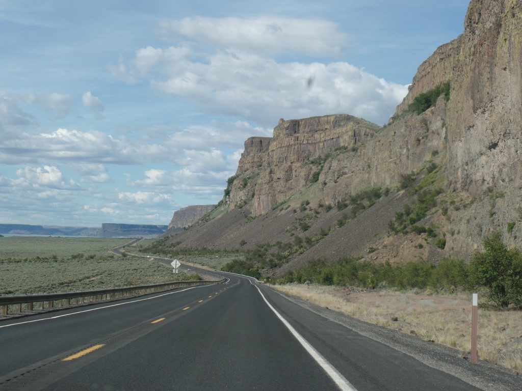
We exited Interstate 90 at George, taking Route 283 which becomes Route 28 at Ephrata. North of Ephrata we turned left onto Route 17 which leads into a valley narrowing into a coulee or canyon as you progress northward. This picturesque valley contains a string of lakes starting with Soap Lake, followed by Lenore Lake, Blue Lake, and Park Lake. In the area from Lenore Lake north, abundant caves can be seen in the ravine walls. The vistas in this off-the-beaten-path route rivaled those of the famous National Parks we were yet to see. Being less than a day’s drive from our home, we must go back one day.
Upon reaching Highway 2 we turned right toward Grand Coulee. After passing through the town, we followed picturesque Route 174 to Wilbur and then Highway 2 to Spokane.
The first night, we stayed at the MyPlace Hotel in Spokane Valley. It was nothing fancy but was clean and comfortable – good value for an overnight stop. The goal for day 2 was to reach Livingston Montana putting us in position for a day of exploring Yellowstone Park.
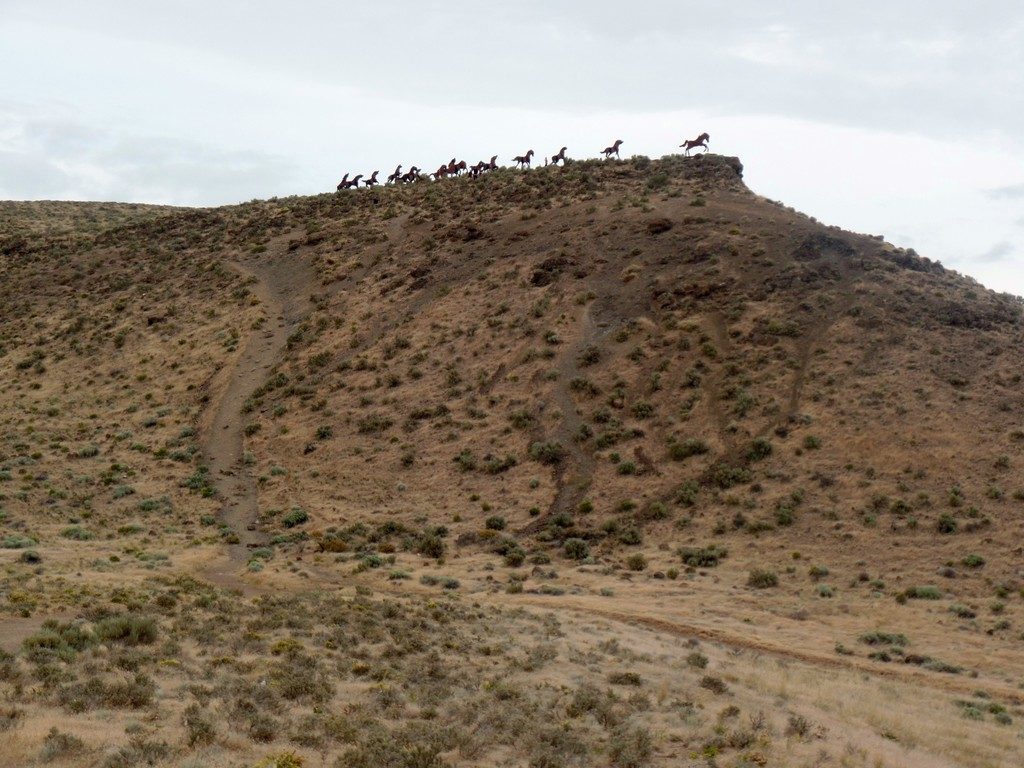
On our first day we stopped by the Wild Horse Monument overlooking the Columbia River in Washington State.
View of the Columbia River from Wild Horse Lookout
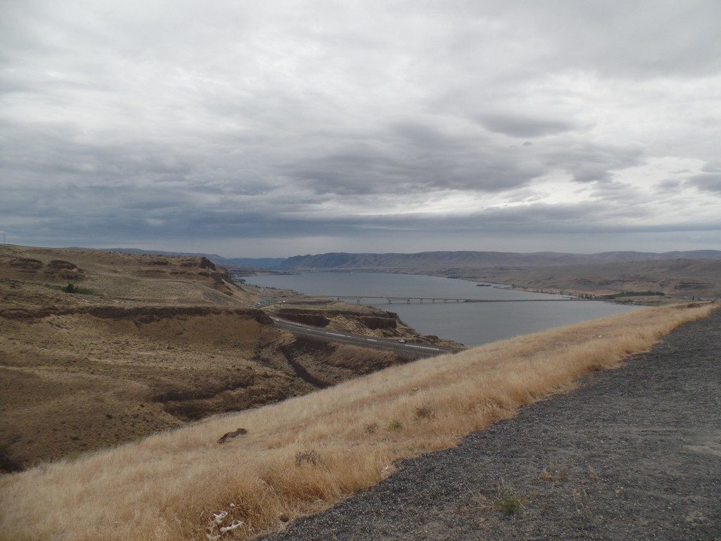
Looking north from Banks Lake Recreation Area, part of our longer “scenic route” on the way to Spokane Valley
Day 2 & 3 – Spokane Valley to Livingston and Yellowstone Park
We arrived in Livingston on a very dark rainy night with a risk of thunderstorms in the forecast for the next day – not very promising for our planned day in Yellowstone Park. The situation worsened when we had to evacuate our room around 1 am upon discovering bedbugs. Ouch, this was certainly the low point of our trip. Fortunately, we had not even unpacked our suitcase and got out quickly so none came with us. We ended up with a sleepless night and headed south toward Yellowstone at the crack of dawn. It was still raining, but conditions improved during the day and the spectacular sights ahead kept us awake and alert in spite of little sleep.
It ended up being in our favour that we had such an early start with so much to see in Yellowstone Park (it is huge). Our ambitious plans included seeing many park highlights while leaving enough time to drive south to Jackson and over a mountain pass to Victor Idaho where we had reserved a nice B&B for the next night. Ideally, we would have stayed at one of the rustic park lodges, but that requires booking about a year in advance, not a great option unless you can be certain of your travel dates.
Traffic in Yellowstone can come to a grinding halt as people stop in the middle of the road when they spot wildlife, not something they should do where there’s no pullout. At one point this behavior brought traffic at Canyon Junction, a major park intersection, to a complete standstill resulting in huge backups in every direction. An angry park ranger had to get the offending cars moving again.
Despite the traffic congestion, we saw everything we set out to see that day. Driving around Grand Loop Road, we spent time exploring Mammoth Hot Springs, Mt. Washburn, the Grand Canyon of Yellowstone and the Lower Falls, West Thumb Geyser Basin, and Old Faithful. We arrived at Old Faithful just a few minutes before it erupted. Tip: If you see a large crowd on the boardwalk as you approach, chances are it is going to erupt soon, The crowds disipate right after it finishes. We also saw a Black Bear with her cubs, Elk, Mountain Goats, and numerous Bison making it a very memorable day.
Planning to spend the next day exploring Jackson Wyoming, we drove an extra 30 minutes over a high mountain pass into Victor Idaho where we spent the night at the Fin and Feather Inn, a beautiful upscale B&B for substantially less than a Motel 6 in Jackson would cost.
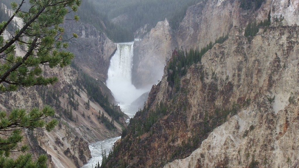
Upper Falls of the Yellowstone – This area is also nicknamed The Grand Canyon of Yellowstone Park.
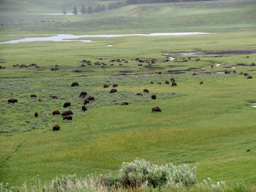
Bison Grazing on lush green grassland in the scenic Hayden Valley
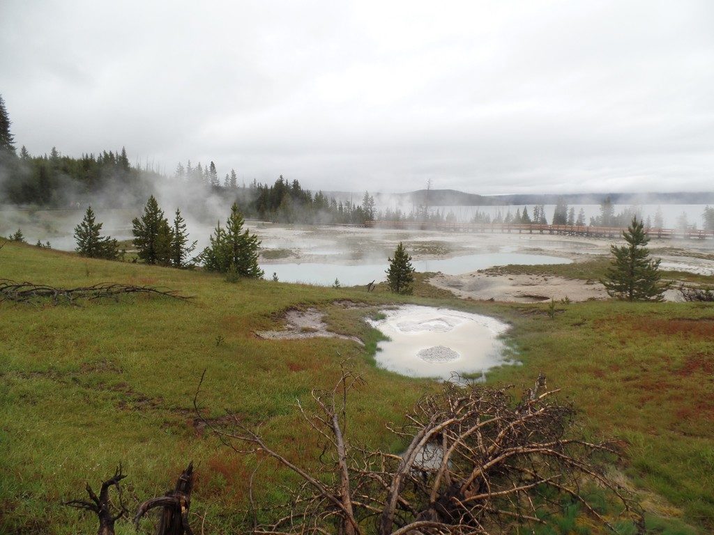
Lots of steam was rising off the hot springs in the West Thumb Geyser Basin
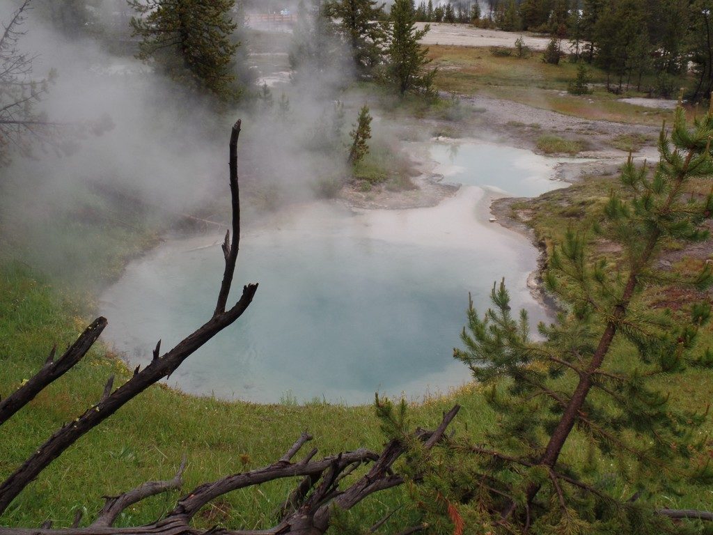
Hot spring pools like this one in the West Thumb Geyser Basin can reach the boiling point. That is why you must stay on the boardwalk
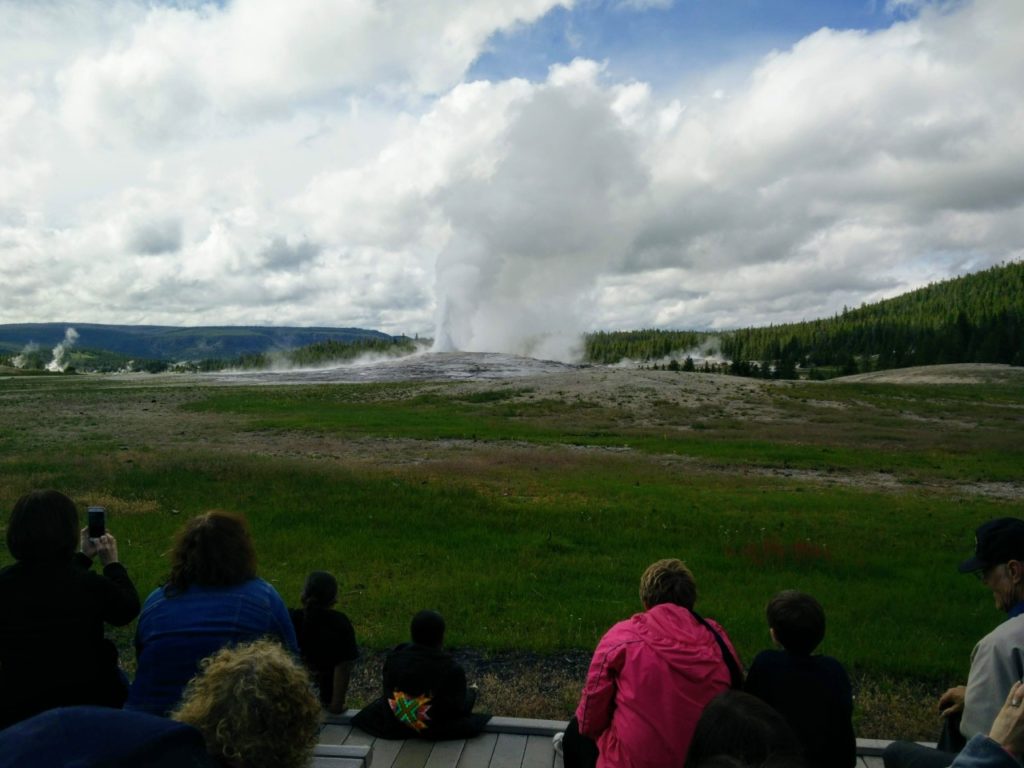
Old Faithful was faithful indeed, showing off its stuff 10 minutes after we arrived at the viewing area
Day 4 – Jackson Wyoming to Afton
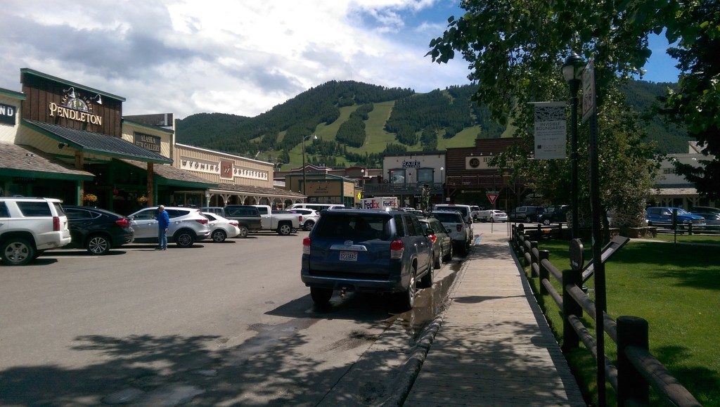
Jackson Wyoming is a fun bustling little town with a real western vibe located in a beautiful valley south of the Grand Tetons and the National Elk Refuge. It also sits at the base of Snow King Mountain, a popular resort for skiing, hiking and other outdoor activities. We visited the Town Square getting the requisite photos in front of the famous elk antler arches. We phoned our kids so they could see us live on Jackson’s main intersection YouTube stream. Following that we hunted for souvenirs in the many surrounding shops and visited art galleries exhibiting beautiful paintings of the local area. We enjoyed our day in Jackson but the town does strike me as a bit of a tourist trap. If we had more time to explore the outdoor areas we would have enjoyed it more, but it was a good day all the same.
Later that afternoon, we drove 2 hours south to Afton Wyoming where we spent the night in a very nice log cabin at a Kodiak Mountain Resort by the highway. We chose Afton to position us farther south in preparation for the long drive to southern Utah.
Western shops and galleries are plentiful around Jackson Wyoming’s Town Square
Day 5 & 6 – Afton to Hatch Utah and Bryce Canyon
On day 5 we began the long day’s drive toward southern Utah. Our next destination was the very small town of Hatch, a place we chose because of its ideal location between Bryce Canyon and Zion National Park. It would be our base for 3 nights. The location was excellent for our purpose and Hatch Station motel offered better value than accommodations closer to either park. The room was clean, our number one priority, but small for a 3-night stay. If we were to go again, we would look for accommodations that are a little larger. The town of Panguitch, about 20 minutes north, is also a good location for exploring Bryce Canyon and Zion National Park, but not quite as convenient to both parks as Hatch.
After having a good sleep and breakfast, we headed for Bryce Canyon. Along the way, we were soon sidetracked by the stunning red hoodoos of Red Canyon in the Dixie National Forest, an area that rivals Bryce Canyon itself (no easy task). This was such an enjoyable area we decided to stop again on the drive back and hike some of the trails adjacent to the highway.
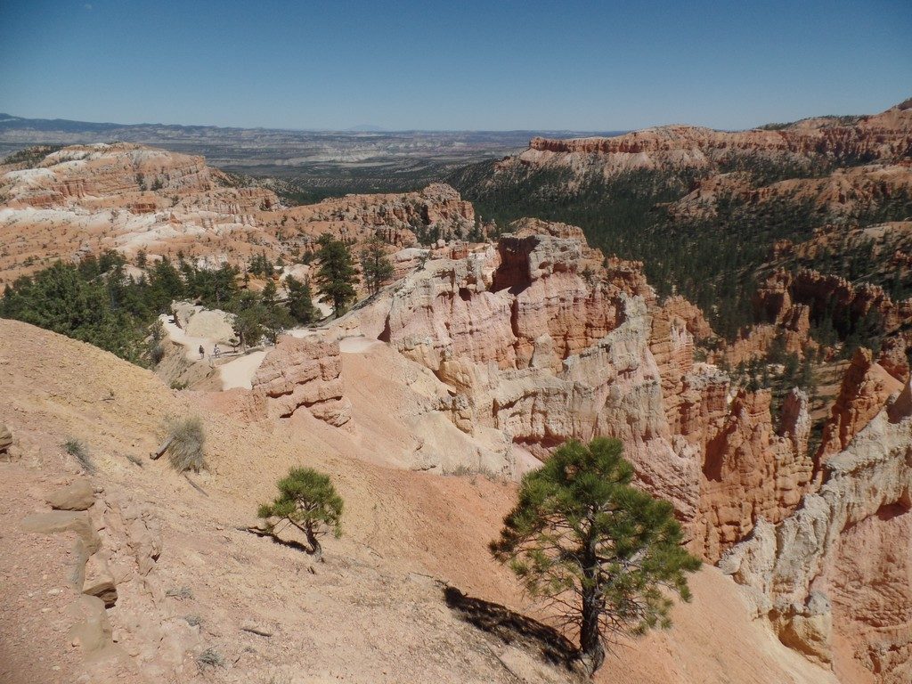
I’d rank Bryce Canyon as one of the top highlights of our entire trip. To say our first view from the edge was breathtaking would be an understatement – it was almost surreal. The park was busy, but not to the point where parking was a problem. We stopped at each viewing area and hiked along portions of the canyon rim. Later, we hiked part way down into the canyon on Queens Garden Trail. For further reading, Just Go Travel Studios has several good articles about hiking trails in Bryce Canyon ????.
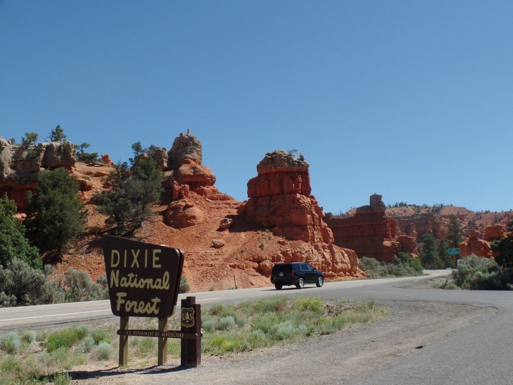
We were first greeted by Hoodoos as we passed through Red Canyon in the Dixie National Forest on our way to Bryce Canyon
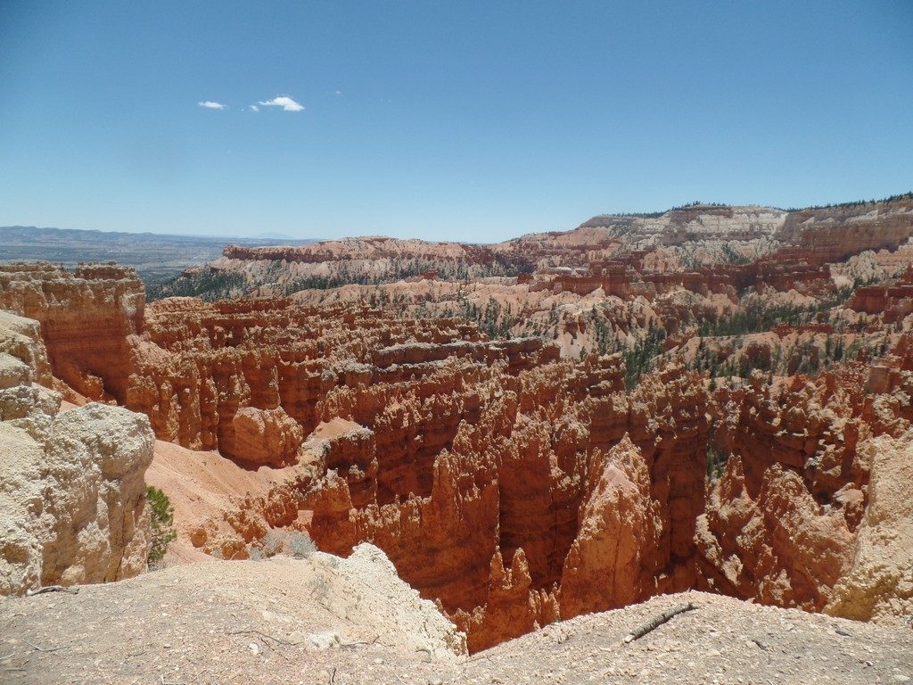
Our first view into Bryce Canyon was almost surrealistic
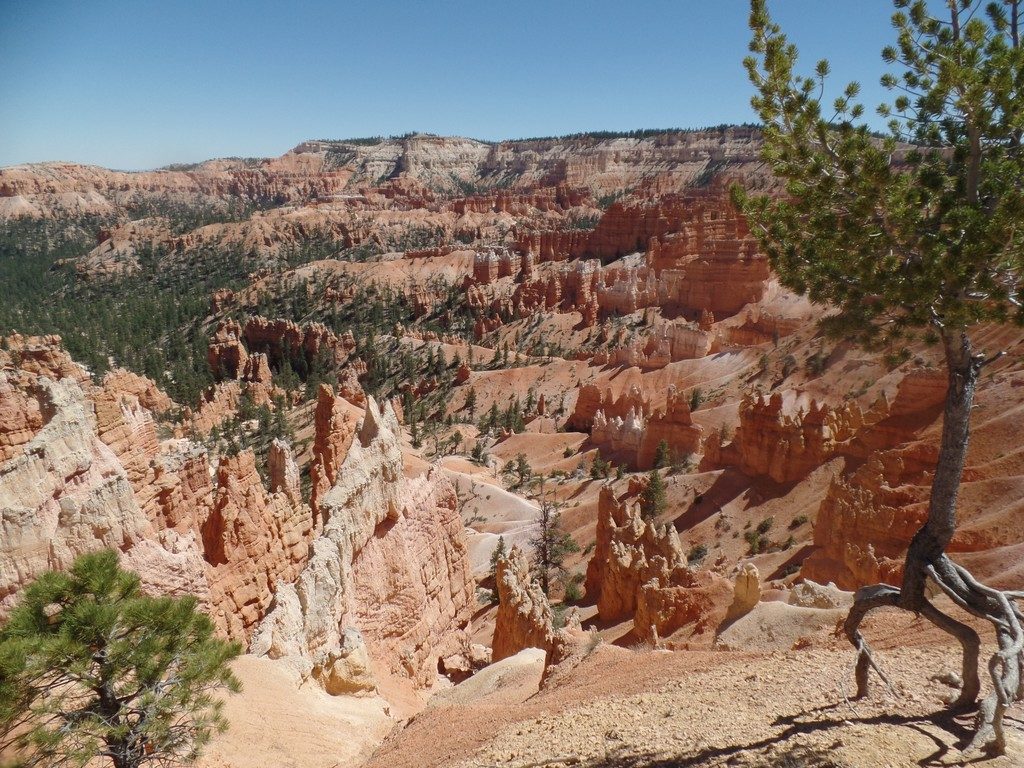
Bryce Canyon from another one of the many viewpoints
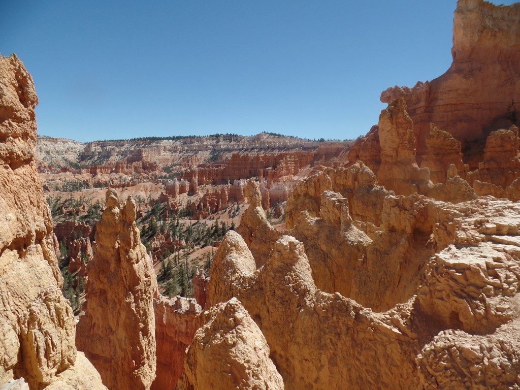
One of many hiking trails that lead down into Bryce Canyon
View from Queens Garden Trail as we hike down among the giant hoodoos
Day 7 – Zion National Park
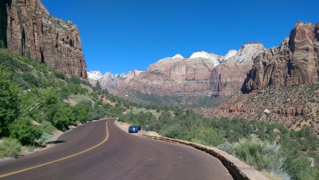
This was our day to see Zion National Park. Following Route 89S from Hatch to Mount Carmel Junction, we picked up State Route 9 also known as the Zion Park Scenic Byway. Beyond the east entrance the road is very narrow and winding. In spite of that, frequent pullouts make it easy to stop and soak in the amazing vistas.
Our route took us through the famous 1.1 mile Zion-Mount Carmel Tunnel that was completed in 1930. While the tunnel does carry two-way traffic it was restricted to one-way alternating traffic when we went through, not surprising as it is narrow and dark and there have been many accidents between larger vehicles trying to travel through the tunnel in opposite directions. In addition to the park fee, vehicles taller than 11’4″ and/or wider than 7’10” including mirrors and jacks must pay an escort fee of $15.00 to drive through the tunnel. This includes most motorhomes and trucks pulling travel trailers. The time of day you can drive through the tunnel with a large vehicle is also subject to restrictions. These vary by season. For more information see https://www.nps.gov/zion/planyourvisit/the-zion-mount-carmel-tunnel.htm
Zion National Park has become so popular that cars are no longer permitted to drive along Floor of the Valley Road. Visitors can ride one of the frequent shuttle buses that make seven stops along this route. You will want to get off at all seven stops as we did. The view from each stop is unique and spectacular in its own way. This system works well and eliminates the traffic jams.
Our goal was to park near the first shuttle bus stop at Canyon Junction Bridge and ride the shuttle bus to explore the Valley. However, we encountered signs indicating parking was full and directing us to park in the town of Springdale beyond the south entrance. The charge for parking in town near the entrance was $20 and these too were full.
We later learned there is free parking farther into town where free shuttle buses transport visitors to the park entrance. From there, they can transfer to the Floor of the Valley shuttle.
Determined to find a parking spot, we re-entered the park through the south gate and returned east along Zion-Mount Carmel Highway. Lo and behold, we found a parking spot on the side of the road just large enough for our Toyota Prius! This was the last spot available before passing through Mount Carmel tunnel again and was within walking distance of the first shuttle bus stop. From there we were able to carry out our plans to see the narrow Virgin River Valley that carves its way through the magnificent mountains that make one feel so small. In spite of the 100°F heat, we enjoyed our day taking in the breathtaking landscapes and geology of this beautiful park. Tip: It is a good idea to bring bottled water and sunscreen along when visiting the park.
We visited all seven shuttle stops and enjoyed walking along the valley trails and craning our necks upward to look a the majestic walls of rock towering high above us.
Traveling in the opposite direction on our drive back to Hatch gave us a whole other perspective of this magnificent landscape.

Looking west along Zion – Mount Carmel Highway as we drive through Zion National Park
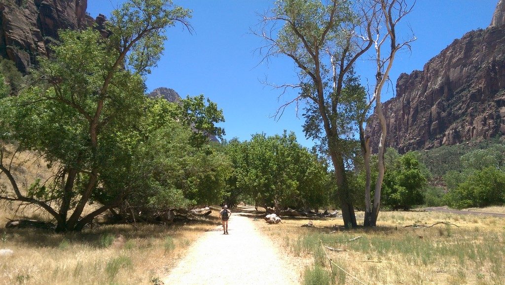
Enjoying a hike though the Virgin River Valley in Zion National Park
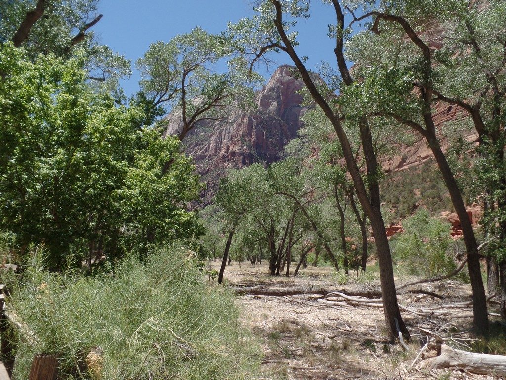
Another part of Virgin River Valley in Zion National Park
Day 8 – Hatch to Grand Canyon National Park and Williams
Our eighth day came with grand plans. We had many miles to cover in one day and we wanted to see the South Rim of the Grand Canyon along the way. Would we have time to do both? Turns out we did.
We began by heading south on Route 89 until we got to the town of Kanab. From here we had a choice of continuing on route 89 or taking route 89A. Route 89A takes a little longer but passes through some different scenery including Marble Canyon. We opted for the latter and didn’t regret the choice. It was a very scenic drive. At Marble Canyon we walked across the Colorado River on the old bridge. It is remarkable to realize this narrow little gorge grows to become the magnificent Grand Canyon less than 40 miles to the southwest. However, driving to the South Rim of the Grand Canyon is considerably further. With great anticipation, we pressed on until we could finally peer into the Grand Canyon for our first time. I imagined this moment for many years and it did not disappoint.
As was our experience with the other National Parks, there were plenty of viewpoints to stop at. Parking was not a problem at any of the pullouts and we stopped at them all. Eventually, we arrived at Grand Canyon Village where we again parked and looked around. The village itself is busy and can be confusing to navigate, but we found a parking spot in front of Bright Angel Lodge and enjoyed dinner in their dining room. The prices where reasonable considering we were in a prime tourist area.
After dinner, we purchased some souvenirs from the gift shop. Following that, we strolled along the walking path skirting the south rim and enjoyed the warm glow and deep shadows created by the setting sun. Since my eyesight isn’t good at night, we didn’t dwell for too long. We still had a one hour drive to Williams Arizona for our next night.
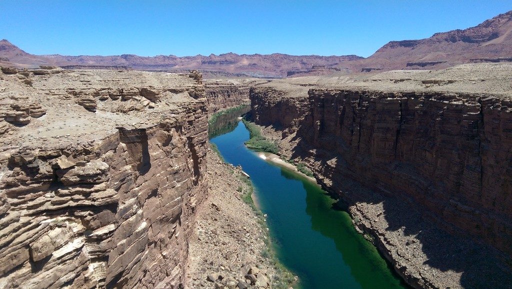
At Marble Canyon this narrow gorge carved out by the Colorado River grows to become the magnificent Grand Canyon about 40 miles downstream
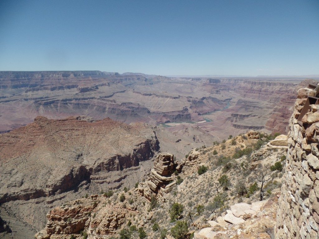
Our first view of the Grand Canyon was from the Desert View Lookout
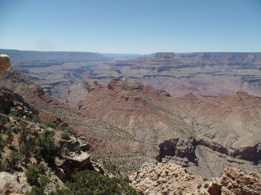
Looking west from the Sourth Rim of the Grand Canyon
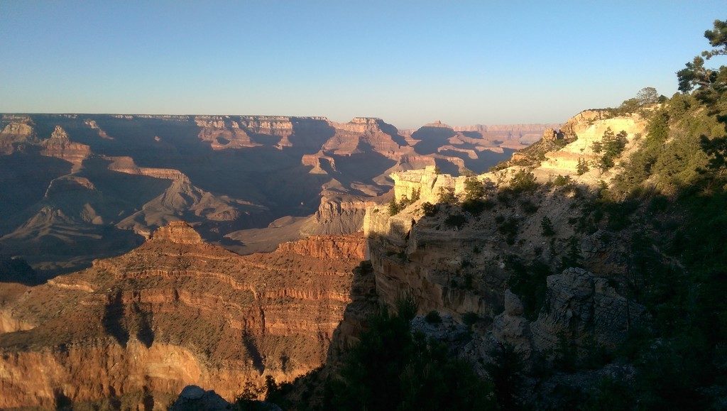
The setting sun casts deep shadows and a warm glow across the Grand Canyon in this view from the Village
Day 9 – Williams to Sedona and Scottsdale
The next morning in Williams, we ate breakfast and then spent the morning exploring some interesting buildings and businesses located along historic Route 66. Williams is an interesting town that takes you back in time with it’s classic cars and other nostalic pieces displayed throughout. It would be nice to spend a full day there, but we had to keep moving. Our goal was Scottsdale Arizona where we would spend 3 nights enjoying accommodations at a resort with a full apartment.
On our way, we drove through Sedona where we planned a 2 night stay on the return leg. This gave us a preview of this unique region. We drove up to the Sedona Airport lookout for an overview of the city. TIP: When we visited we found we could park for free at the airport rather than paying to park right across from the viewpoint. It’s only a slightly longer walk. On the road up, we saw a small parking pullout with a trail leading to a rocky knoll. We took note of this as something to do on our return visit.
As we closed the distance to Scottsdale, we started to see increasing numbers of Saguaro cactus on the hillsides, something I’ve always wanted to see close up and in person, rather than just pictures.
With help from our GPS, we safely arrived at Scottsdale Links Resort. We got an excellent rate on this property through Booking.com, partly because it is the quiet season in Scottsdale and partly because they were promoting timeshares at the resort. They invited us to a presentation a few times. We weren’t there for that and declined.
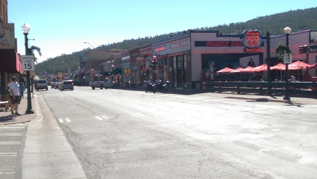
Before leaving Williams we spent some time exploring the historic section of Route 66 that passes through this town
Day 10 and 11 – Scottsdale
We were at the halfway point of our 3-week road trip. This was planned intentionally as a time to recuperate and get our laundry done, thanks to the in-suite laundry facilities. The apartment was spacious and had a good size deck, overlooking the golf course, where we could sit and enjoy a quiet drink.
The temperatures soared to 104F, dropping slightly into 90s at night. It was a dry heat so it didn’t bother us, especially with our air-conditioned apartment and spending much of our day relaxing and swimming at the pool. The resort has two pool areas, one for families and children and another just for adults which was much quieter to our liking.
On the second morning, we visited the McDowell Sonoran Preserve a few minutes drive from our accommodations. In spite of going in the morning, it quickly got hot, but we enjoyed walking around the loop trail which was fascinating and had excellent signage about the desert environment including the plants and animals. Living in a temperate climate, I found this area most interesting. If we were carrying more water we would have spent more time there, but, for me, it was an unexpected highlight of our trip.

During our relaxing break in Scottsdale, a visit to the McDowell Sonoran Preserve turned out to be a highlight of our trip and I got to cross seeing a giant Saguaro Cactus off my bucket list
Day 12 and 13 – Back to Sedona
After enjoying two full days to relax and recuperate it was time to continue our journey. Going to Scottsdale we took Route 89A, however, we returned to Sedona on Route 179 through the Village of Oak Creek. This route offers dramatic vistas of the unique landscape as you drive by Bell Rock, Courthouse Butte and the iconic Chapel of the Holy Cross. After settling into our modest motel, we bought some groceries, put together a quick meal and went for a relaxing swim in the pool. Due to the higher elevation, it was still warm, but significantly cooler than Scottsdale.
The next morning we drove up Airport Road to the trailhead we saw when we passed through Sedona on Day 9. This trail leads up to a rocky knoll called Airport Mesa. From there, we enjoyed expansive views in every direction. We hiked part way along Brewer trail which leads downhill to Brewer Road in Oak Creek.
That afternoon we drove to Chapel of the Holy Cross. Built in the 1950s on a red rock butte, this iconic landmark is deceptively modern. They have a lower and an upper parking lot. If the upper lot is full, they provide a free shuttle service from the lower lot by means of a golf cart. The fabulous views from this vantage point definitely make this a worthwhile side trip. Later, we spent time exploring a number of unique shops and galleries on the way back to our motel.
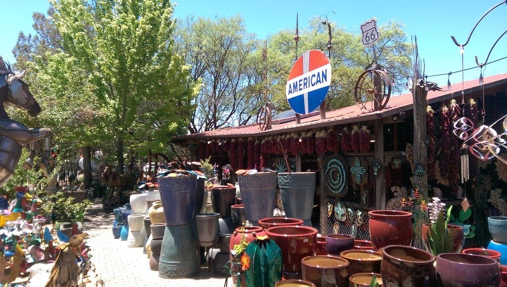
Planters and yard ornaments on display at Son Silver West Galleries in Sedona
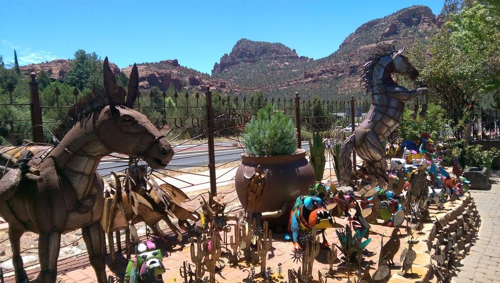
Hand crafted metal sculptures for sale at Son Silver West Galleries in Sedona
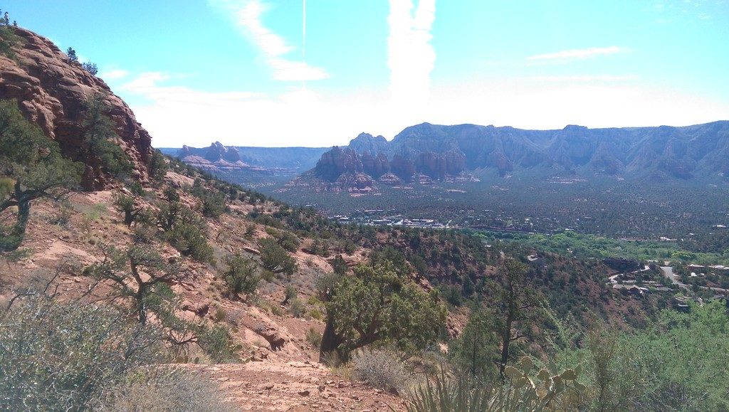
This view toward the Village of Oak Creek was photographed from Brewer Trail that starts from the Sedona Airport Mesa
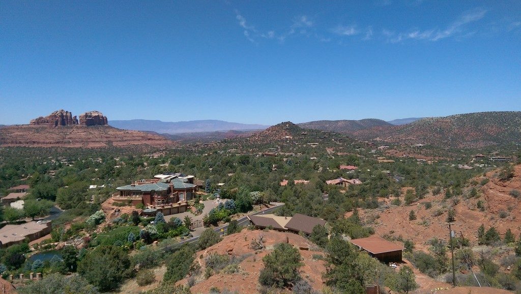
View of Sedona from the Chapel of the Holy Cross
Day 14 – Sedona to Monument Valley to Blanding
After two nights in Sedona, our goal included a long day’s drive which took us through Monument Valley, another place I have always wanted to experience in-person. Our destination for the night was Blanding Utah. We chose Blanding bcause of its location between Monument Valley and Arches National Park. This gave us this option to return and spend more time in Monument Valley or to do a day trip to Arches National Park. More on that later.
Our journey took us through vast tracts of the Hopi and Navajo Indian Reservation. Monument Valley is entirely located within the latter. Nearing Kayenta we could see rocky buttes similar to, but less dramatic than, those in Monument Valley; a hint at what was to come. Reaching Kayenta, we turned left and began the spectacular drive along Route 163 flanked by eroded sandstone buttes rising high above the Colorado Plateau. Like most natural wonders, photographs and videos don’t leave the same impression as being there in person.
One thing we discovered when driving through the reservations is there’s a charge to access some areas. I understand the reason for doing so; what I don’t understand is that the fees are not disclosed at the turnoff point, enabling an informed choice. You see a sign for a scenic viewpoint, take the turnoff, then follow the road for some distance when you suddenly find yourself at a gatehouse where a fee is requested. You’re free to turn around and go back, but it wastes time and may make you feel awkward. We experienced this before the Grand Canyon, in Sedona and at the turnoff for the Monument Valley Interpretive Center. As it was, we skipped the interpretive center but did capture some good photographs of the area before resuming our drive.
Mexican Hat was the next little town we passed through as we left Monument Valley in our rearview mirror. It is aptly named after a large flat rock perched precariously on top of a narrow rock – truly something to marvel at.
The remaining miles to our destination of Blanding passed quickly. There, we stayed for 2 nights.
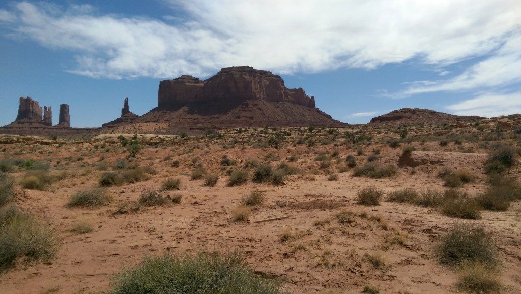
The incredible sandstone buttes of Monument Valley

A final look back where we drove from before heading north out of Monument Valley. The distances appear vast, but the drive goes surprisingly quickly.
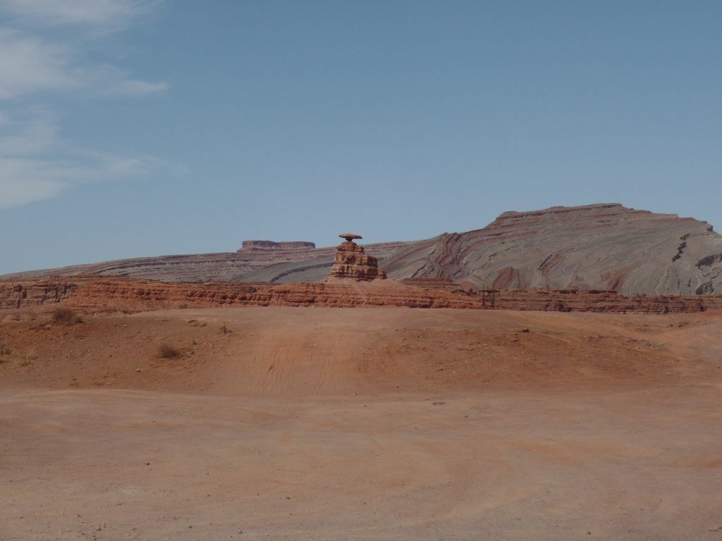
It was immediately obvious where the town of Mexican Hat got its name when we saw the 60 foot wide sombrero-shaped slab of rock precariously perched on a much smaller rock. Nature is truly amazing.
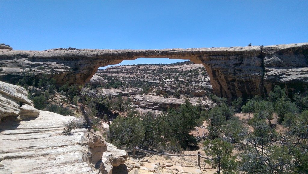
Day 15 – Natural Bridges National Monument
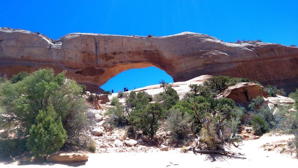
Our stay at the Stone Lizard Lodging in Blanding provided us with a superb home-cooked breakfast buffet giving us a good start to the day. We originally planned a day trip to Arches National Park near Moab but, on the previous day’s drive, we noticed a sign for the turnoff to Natural Bridges National Monument. This was a place I had not heard of before so I looked it up on my phone and read many comments about what an amazing place it was and also how quiet it was compared to Arches National Park. It was also a shorter drive to get there from Blanding. I knew we would not have time to see both so after reading the positive reviews we decided to visit Natural Bridges.
While I am certain Arches National Park would have been spectacular, we were not disappointed with our decision. The scenic and beautiful drive to Natural Bridges and the area itself proved to be one of the highlights of our trip. It was very quiet. A one-way road that loops around the park offers stunning viewpoints of the natural bridges created by water as opposed to the arches in Arches National Park that were created by wind and blowing sand.
Hiking trails lead down below a number of the natural rock bridges from the various viewpoints. Some are more difficult than others. We chose to take the trail from the last viewpoint which is one of the easier trails. To walk down and see this natural wonder from underneath is an amazing and humbling experience. Nearby, massive slabs of granite standing on their edges made me ponder exactly how they came to rest in such a precarious position.
We returned to Blanding for dinner and afterward had time to relax in the garden area behind our motel. This was a nice reprieve before our drive to Colorado the next morning.
Part way down the trail to the last Natural Bridge at Natural Bridges National Monument
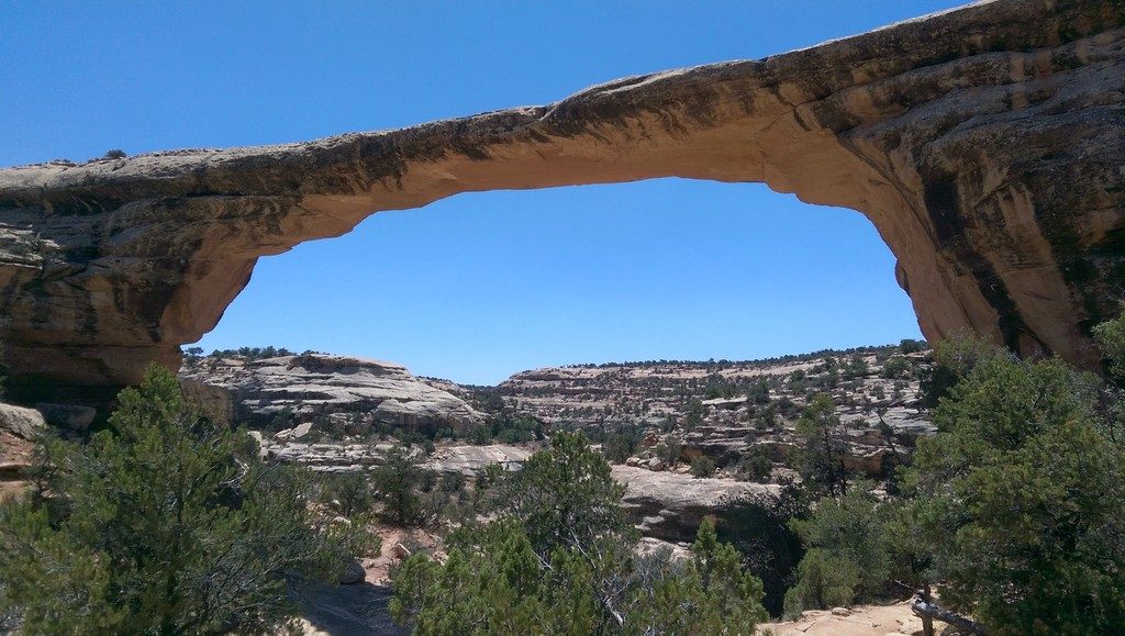
Looking up from under the last Bridge at Natural Bridges National Monument
Day 16 – Blanding to Canyonlands and Wilsons Arch to Telluride and Ouray
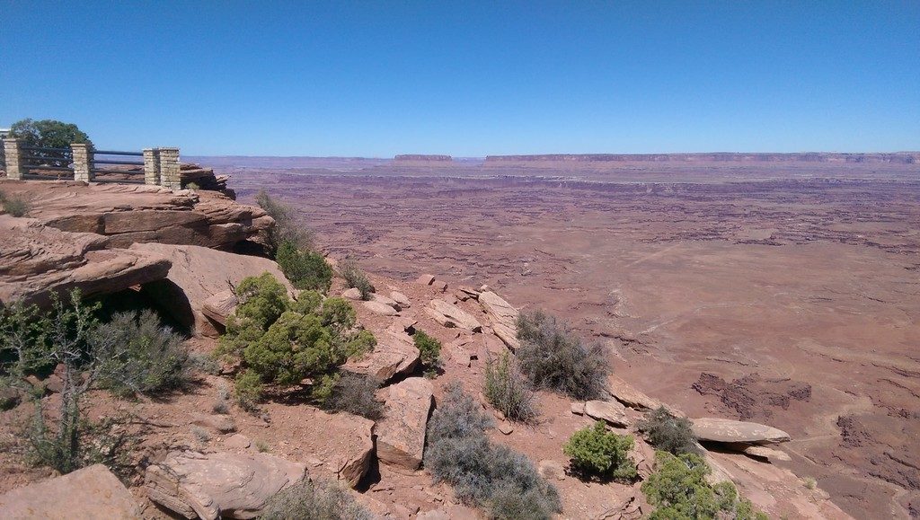
On this day we had a considerable drive ahead and wanted to see lots along the way. Our goal by day end was Ouray Colorado, but we were not taking the quickest route. We had numerous options, any of which would have been awesome. We chose to head north on highway 191 to Needles Overlook Road. Needles Overlook was a side trip requiring a one hour round trip off the main highway. If ever an hour was well spent, this was one of those times. The narrow, but fully paved, 2 lane road traverses the plateau passing many interesting rock formations as it gets closer to the rim of Canyonlands National Park. We did not pass a single vehicle on this road both coming and going, however, we did pass a group of deer beside it.
When we arrived at Needles Point Lookout and peered over the rim into the vast Canyon, considerably wider than the Grand Canyon. We were spellbound. In some sense, it is even more breathtaking than the far busier, and more famous, Grand Canyon. Like the Grand Canyon, it is carved out by the Colorado River which meanders along the Canyon floor, barely visible from our high vantage point.
Our route continued north on Route 191 where we stopped right in front of Wilsons Arch. With no time to visit Arches National Park, we still got to see an incredible natural arch created through erosion from wind and sand.
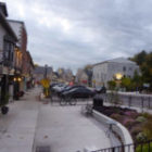
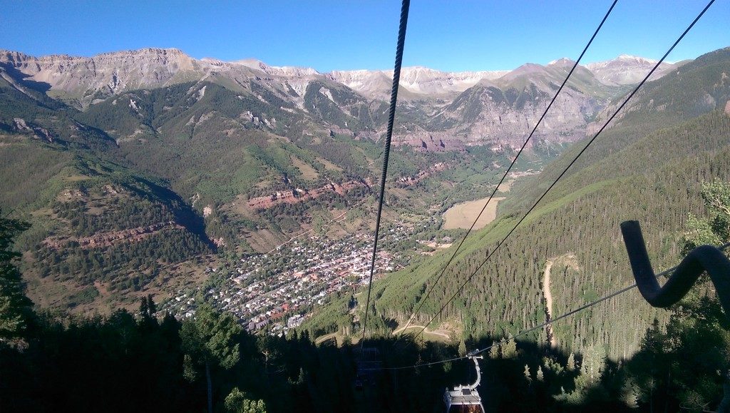
Having more miles to drive and another stop along the way, it was time to continue through the ever-changing landscape. We turned onto Route 46 which leads east and southeast. In due course, we crossed into Colorado and arrived at Mountain Village perched above the town of Telluride. Not our final destination for the day, but another stop along the way, Telluride is a very picturesque town nestled in a deep valley in the Colorado Rockies. We drove to Mountain Village first for two reasons. First, parking is scarce in Telluride whereas you can park for free in Mountain Village. Second, from the public parking lot, you board a free Gondola for a spectacular ride over the ridge and down into the town. This 13 minute Gondola ride has been operating since 1996 and functions as more than just a ski lift. It provides public transportation between the two towns saving commuters a 20 minute 8-mile drive. Adventurous cyclists utilize the bicycle racks on each gondola for accessing the top of the mountain bike trails. The town of Telluride is small enough to explore on foot.
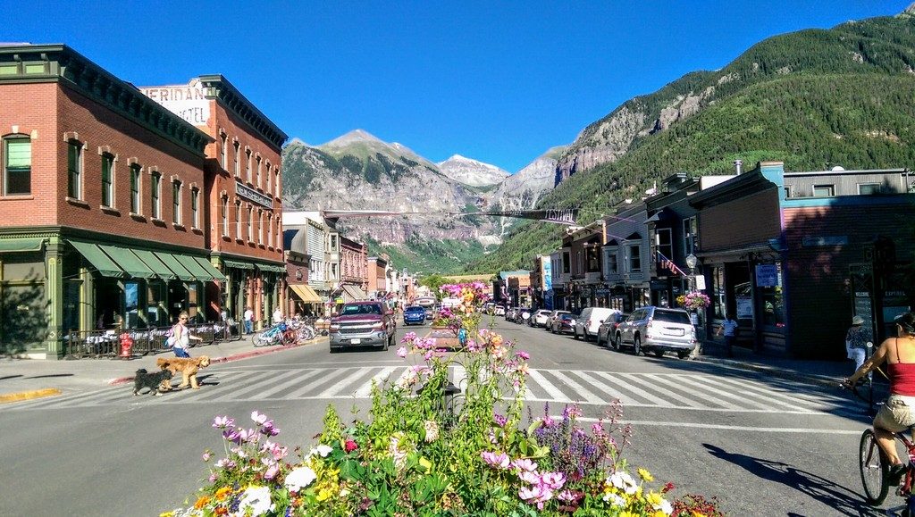
After stepping off the Gondola into the town we walked a few short blocks to Colorado Avenue, Telluride’s main street. Like several small towns in the Colorado Rockies, Telluride started as a mining town in the 1800s. Due to its spectacular setting and changing times it has transitioned to a popular year-round playground and tourist destination. We enjoyed walking around and exploring some of the unique shops and galleries before deciding where to eat dinner. After a relaxing meal, we explored the town some more. A little before sunset we headed back to the lower Gondola station, once again enjoying the stunning views as it carried us up the mountain to our car.
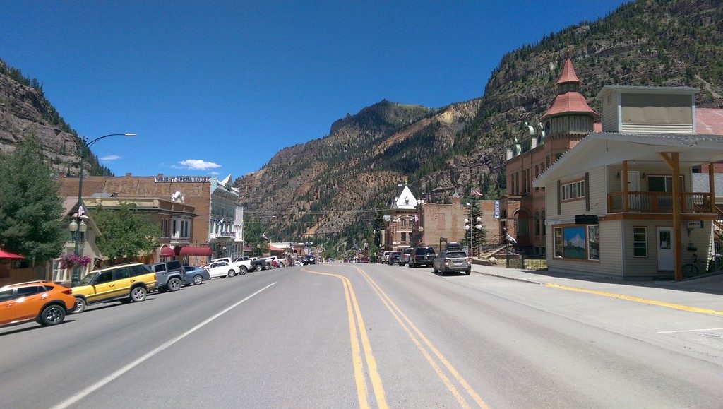
Our final destination on this full day of travel was the town of Ouray, another former mining town that is now a popular destination for outdoor enthusiasts. It’s located about an hours drive from Telluride in the next valley to the east.
When we pulled into Ouray we looked for the Matterhorn Inn where we would be spending the next two nights and checked ourselves in, tired, but pleased with all we had seen in a very full day of travel and exploring.
Ouray is a pretty location, not as spectacular as Telluride, but still very picturesque and rugged. Accommodation rates are on the high side for what you get, but less expensive than in Telluride. Ouray has many historic buildings, some containing unique shops and galleries. There are plenty of places to dine. Like Telluride, you will not find any of the familiar franchise stores or restaurants. Off course, that is part of the charm. Several companies in town offer Jeep rentals and tours to explore the surrounding mountains.
Staying for 2 nights gave us a full day in Ouray. After eating breakfast just up the road from our hotel, we walked around the town checking out some of the unique shops and art galleries. In each block along Main Street, information placards on pedestals describe the history of the historic buildings. At the north end of town is a park and a large swimming pool filled by a natural hot spring from the mountainside. It’s a popular location with locals and tourists alike, although the price of admission surprised me, certainly an expensive proposition for an entire family.
Later, we drove north from Ouray to the nearby town of Ridgway and spent part of the afternoon exploring it. The critically acclaimed Western, True Grit, released in 2010, was filmed in Ridgeway and the surrounding area. You can look for some of the film locations with the help of a printed guide from the Visitor Center or, on Fridays at 11am, you can join a guided walking tour from the same location. We enjoyed an old fashioned ice cream before returning to Ouray for our second night.
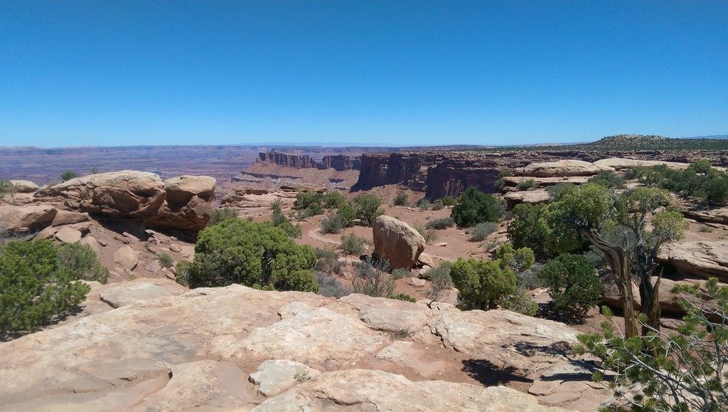
Our side-trip to Needles Overlook in Canyonlands National Park was a major highlight of our roadtrip
View to the south from Needles Overlook
Wilsons Arch, located right by the highway, was the next stop along our route
Descending into Telluride on the free Gondola was great fun with spectacular views
Looking east on Colorado Avenue, the main street in Telluride
Looking north along Main Street in the historic town of Ouray Colorado
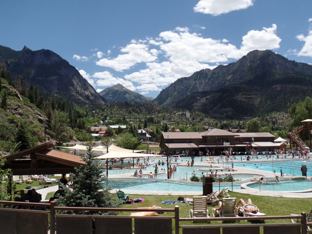
Ouray Hotsprings Pool in Fellin Park with the town and mountains beyond
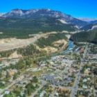
Day 17 and 18 – Ouray to Ogden to Baker City
Getting close to the end of this memorable vacation, and it was time to head towards home – a full 3-days drive but we chose a more leisurely 4 days. Our first day brought us to Ogden, Utah just north of Salt Lake City. Rather than driving through Salt Lake City and the associated traffic we made our way north via Route 189 past Deer Creek State Park and Park City. We followed Route 80 north and then Route 84 west through the mountain pass to our hotel, a Best Western Plus, located just off the highway.
After a good nights sleep, we headed out the next morning toward Baker City in southeast Oregon. At Twin Falls Idaho we stopped for a bite to eat and then visited Shoshone Falls Park on the Snake River. After checking into our motel in Baker City we still had time to drive into the historic downtown core where we walked around and explored many interesting historic homes and buildings. It was Independence Day, so everything was closed and it was very quiet as all the celebrations were happening on the outskirts.
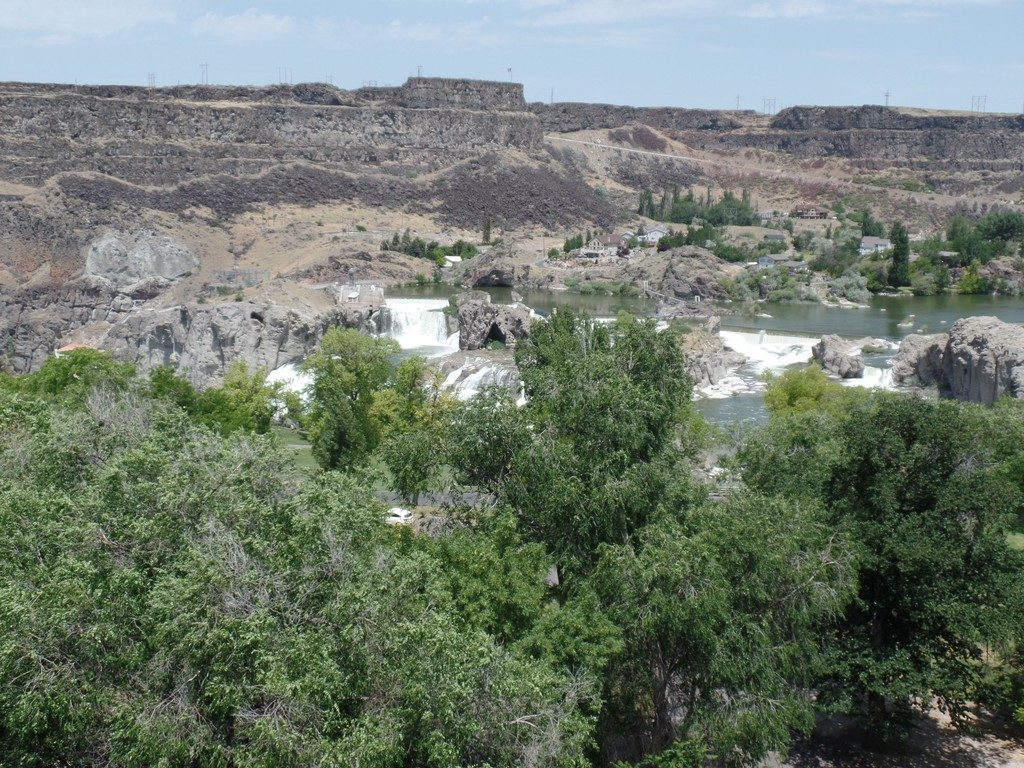
On our way between Ogden and Baker City we took a little detour to see Shoshone Falls in Twin Falls, Idaho
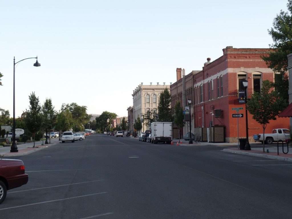
We enjoyed walking around the historic downtown area in Baker City
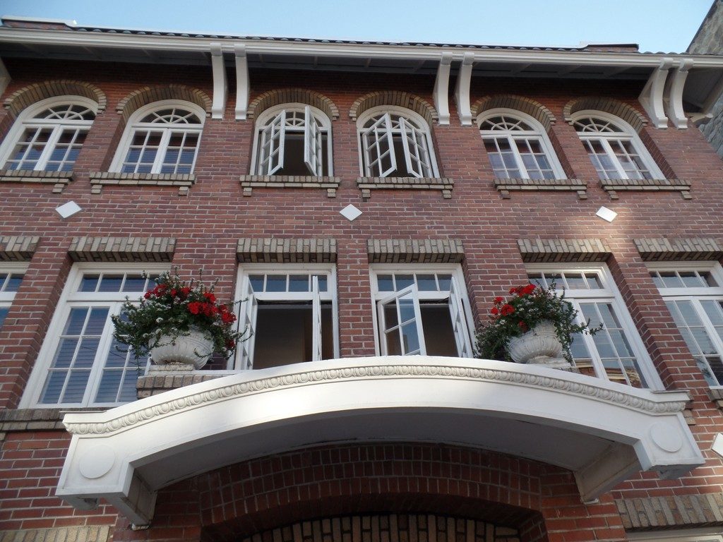
Front facade of an old apartment building in Baker City Oregon
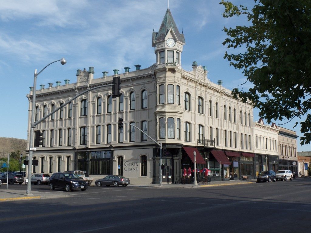
The Geiser Grand Hotel in Baker City
Day 19 and 20 – Baker City to Moses Lake then Home
We could have pushed through and made it home the next day but opted for one more stopover in Moses Lake midway between Spokane and Seattle. We stayed at the Best Western Plus overlooking Moses Lake. This was about a 4-hour drive from Baker City. After settling into our room, we enjoyed a swim in the outdoor pool and later walked along a path between the freeway and lakeshore to nearby Blue Heron Park. After exploring the small park and relaxing on the pier, we returned and enjoyed the sunset from our hotel room balcony.
On our final day, we did not have too long of a drive so we enjoyed a leisurely breakfast that was included in our stay before heading out. We took a slightly longer route in order to drive through Leavenworth, a Bavarian-themed town that we visited the previous year. This route avoided driving through Seattle and the inherent congestion. What we did not anticipate, was traffic congestion driving into Leavenworth. It’s far more crowded in the summer than when we visited it in September. Once we got into the town we stopped for a break and a picnic lunch we had prepared before leaving Moses Lake. From there it was just a little over 4 hours drive to our home including a short lineup at the border.
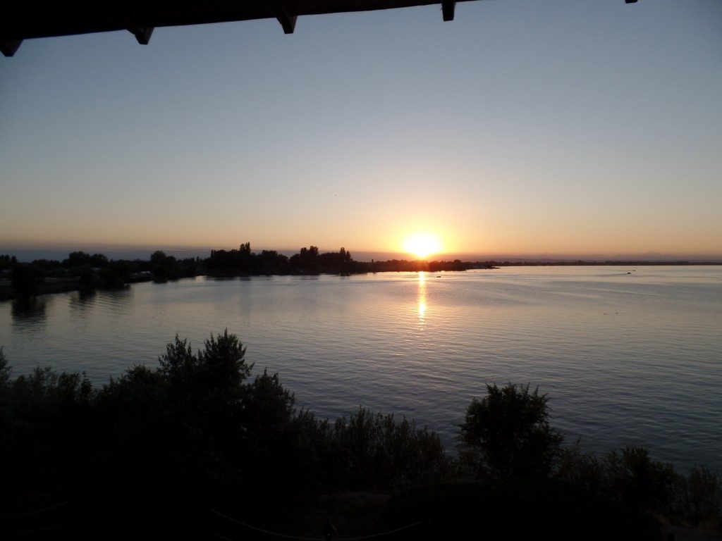
Watching the sunset over Moses Lake Washington from our hotel balcony on the eve of our drive home
Summary
All in all, this was a fabulous and memorable trip to parts of the USA neither of us had been to before. It was not without some hiccups along the way, some of which I have not mentioned, but overall the trip went very well. Our Toyota Prius was both reliable and frugal as it always is. Fuel cost us less than $500 for the entire trip helping to offset the cost of accommodations.
We had an ambitious agenda for three weeks but, with the exception of Arches National Park, saw all of the places we set out to. Indeed one could spend far more time, even a lifetime, exploring each of these areas, but we sure saw many incredible land formations and diverse regions in the time we had. The trip did not feel overly rushed. Having our accommodations pre-booked and carefully planning driving distances to avoid excessively long days helped a lot.
Would we do it again? We’d certainly love to see some of the places we visited again. Yellowstone and Zion National Parks were both fabulous but, personally, I would be more interested in a repeat visit to Bryce Canyon, the Grand Canyon, and Canyonlands National Park. Also, we really enjoyed our time in Scottsdale Arizona. The resort was a great place to just relax and the desert reserves are interesting to explore. Perhaps we will do a shorter version of this trip sometime in the future, but other trips including another road trip across Canada are higher on our bucket list for now. In any case, if you have not dedicated a vacation to visiting some of these incredible national parks, I would highly recommend it.